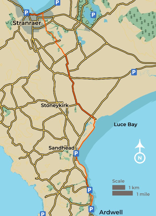
Leaving the village of Ardwell the route stays close to the sea, often just above the strandline of the shingle beaches.
By the time the route reaches the village of Sandhead vast sand flats are revealed at low tide and the prevailing wind blows a constant supply of sand to create sand dunes at the head of the bay. Skirting round a sand quarry and bombing range the route continues north along country lanes between gently undulating farmland and passes through mixed woodlands before arriving at your destination, Stranraer.
The shingle and sand beaches on the shores of Luce Bay are edged by a luxurious growth of plants that are seaside specialists and ancestors of vegetables we eat today. With deep tap roots sea beet, sea radish and sea kale all thrive at locations where other plants would struggle to survive. Sea beet is a common sprawling plant with glossy green leaves while sea kale with its distinctive grey-green cabbage like leaves is less common. Abundant on this shore is sea radish, a tall ungainly plant with small yellow flowers and coarse hairy leaves that has a spicy flavour that taste like a combination of cabbage, wasabi and radish. It has beaded seed pods and the spherical seeds are spread by sea currents and washed up in the strandline all along the coast.


Overshadowing the village of Sandhead is a flat topped conical mound surrounded by the remains of a defensive ditch. Little is known about Balgreggan Motte, sometimes referred to as moated homestead, but it is likely to have been built by a powerful Anglo-Norman noble who had been granted the land by a Scottish King. On the mound would have been a timber castle surrounded by a tall palisade and a gated entrance. Perched on the edge of an old sea cliff, the location would have provided extensive views across the bay. The motte was damaged by the construction of a lookout post during World War Two, of which only a concrete base can now be seen, and the motte remains as a prominent landmark.
early Christian memorial stones from ~500AD
Some of the earliest known Christian memorial stones in Scotland, indeed Britain, are located at Kirkmadrine Church just a few miles inland from Sandhead. The church is a product of the 19th century, but the displayed memorial stones date to around 400-600 AD. Find the stones behind glass on the church building. Great views are available from this vantage point when clear.
Sandhead Village walk
The village of Sandhead lies at the western side at the head of Luce Bay. There is plenty of car parking on the shore and it is safe to use this short circular walk even when the red flag is flying to warn of the firing range in action.
The walk takes you along the beach towards the sand dunes at the head of Luce Bay. It then turns away from the beach taking you through the sand dunes and through the Sands of Luce Caravan Park before returning to the village along a roadside path.

East Coast
First settlers
Numerous archaeological finds of flint fragments and pottery in Torrs Warren show that in an age before metal people used the area to make sharp-edged stone tools. The low land at the head of Luce Bay must have been a sheltered spot where suitable stones could be found. The hunter gatherers had a good knowledge of the land and may have kept returning to the same coastal location to make their tools.
Abandoned target base
Three large cones can be seen in the shallow northern end of Luce Bay just above the low water mark. These are the remains of triangular bombing targets built in 1937 by the contractors who had constructed the RAF West Freugh airfield nearby. The three concrete cones that formed the base of a triangular target have been slowly disintegrating but provide a convenient perch for cormorants. The bay is still used for testing bombs and although access is restricted when red flags are flying the footpath skirts round the firing range and is always open.
Rabbit Industry
Torrs Warren, at the head of Luce Bay is the largest area of sand dunes in south west Scotland. On the coast the mobile dunes are stabilised by lyme grass and marram grass while further inland the dunes have been fixed and have become acidic heathland dominated by heather. Torrs Warren was once managed as an enormous rabbit farm which was an excellent way of gaining an income from poor quality sandy soils. In the mid 1800s it was estimated that 18,000 rabbits were killed every year. Their pelts were exported to England while their carcases were sold locally.
Unusual seashells
On the strandline a remarkable selection of seashells can be found from pretty topshells to the long thin shells of razor clams. Perhaps the most unusual is the spiral cone of the woody canoe-bubble, Scaphander lignarius, a species of sea snail which burrows on the muddy sea floor in search of worms and bivalves. The oddly shaped shell has a distinctive wood grained pattern and is often washed up on the shore near Sandhead, particularly in winter.


Stranraer
This section ends here in Stranraer,
located at the head of Loch Ryan.
Stranraer
Located at the head of Loch Ryan your destination for this section is Stranraer, the largest town in the area. It grew in importance as the ferry port connecting south west Scotland with Belfast and Larne in Northern Ireland.
The ferry service moved to nearby Cairnryan but the port remains one of the main industries in the area alongside tourism and farming.

| Start | Ardwell |
|---|---|
| Finish | Stranraer |
| Distance | 20 kms / 12.5 miles |
| Height Range | 0 – 40m |
| Total Ascent | about 80m |
| Grade |
Easy |
| Supplies | Stranraer is a large town with many shops and several supermarkets. There is a small shop and restaurant in Sandhead. |
| Facilities | Public toilets are available at Ardwell, Sandhead and Stranraer |
| Public Transport | Trains and ferries to Stranraer. Buses from Stranraer to Ardwell. For further information visit TravelineScotland.com |